MicroIMU™ from SONASEARCH
The MicroIMU™ is a full gyro-enhanced Attitude and Heading Reference System (AHRS) 3-axis electronic heading reference system configured as a North-referenced downhole directional survey and orientation tool intended to map oilfield wellbore deviation.
The MicroIMU Technology will track the twists, turns and corkscrews of the wellbore, reporting and modeling the results in 2-D and 3-D. The MicroIMU Technology tracks X (delta longitude), Y (delta latitude), and Z (depth) in tenths of a foot relative to the survey starting position (wellhead) so that when an anomaly is spotted at position XYZ, it can be identified at X degrees rotation (relative to true North), Y degrees pitch (relative to horizontal) and Z foot depth (relative to the earth's surface).
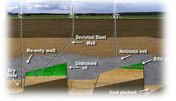
One intended use is Wellbore Mapping i.e., determining the exact location of the wellbore in 3-D space at any point along the wellbore. The increasing trend in crowded offshore drilling for optimizing production requires great emphasis on avoiding collisions with offset wellbores in developed fields. Collision with a producing well can cause a loss of well control, resulting in a significant impact on productive time and income from shut-in wells.
- Automated, computer-controlled search pattern and anomaly recognition ensures complete search coverage and detection of all problem areas.
- Instrinsically safe for operation in the most hazardous environments: H2S, gasoline kerosene, diesel, fuel oil, crude oil, etc.
- Accurate, reliable steel thickness measurements despite the presence of common tank sediments: rust, soil, water and small debris that escaped the filers.
- Inspection point spacing less than or equal to 1/4" to reliably detect corrosion areas measuring less than or equal to 1" in diameter.